Automatic Calculation of Height
When defining points, boreholes and points of ground water table the program in some cases automatically calculates the point height (z-coordinate) and eventually the layer thickness. This function is particularly valuable when editing terrain or layers.
The possibility of height calculation depends on the status of generated terrain:
- If no terrain is generated, the height is not calculated and the respective field remains empty (blank).
- If terrain is generated for the current data (displayed on the desktop in a non-transparent mode and in regimes Generation, Point constructions, Line constructions and Launching also in a color mode), the required values are then automatically calculated from the model of terrain - for a point it is the z-coordinate, for a borehole the program further determines the layer thickness and possibly also the depth of the ground water table - when a point or a borehole is specified the status of generated terrain is changed and the drawing is switched to a transparent mode (the terrain is generated for the original input, not for the current input).
- When the terrain is generated, but it is not the current one, the z-coordinates and layers thicknesses are automatically calculated for the last generated terrain.
Information regarding the terrain status (not generated, generated, generated for the original data) are displayed on the vertical toolbar. The frame "Generate" allows for terrain generating or removing the generated model.
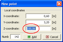 Dialog window - add new point and calculate the Z-coordinate
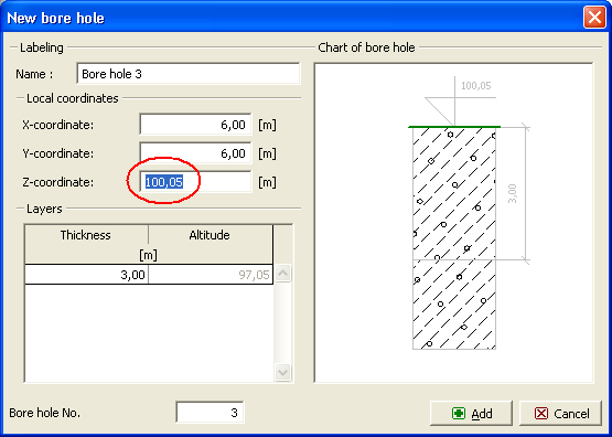 Dialog window - add new borehole and calculate the Z-coordinate, thickness of GWT and layer thicknesses