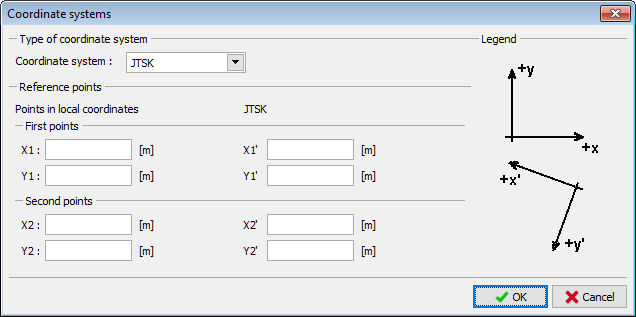
On-line contextual Help
/
Terrain
The "Coordinate systems" dialog window allows for defining the type of the global coordinate system.
Essential advantage is the possibility of specifying the coordinates of points and bore holes both in the local and global coordinate systems and switching between the two systems.
Orientation of the global coordinate system with respect to the local one is defined using two points, where one point is always introduced in the local coordinate system and its image in the global coordinate system.
Direction and sign convention is displayed for each type of the global coordinate system in the legend chart.
Dialog window "Coordinate system"
Language: english
Company Fine develops structural engineering software with main focus on geotechnical software and structural engineering analyses.
A Fine építőmérnöki szoftvereket fejleszt, elsősorban statikai és geotechnikai programokat.
Společnost Fine se zabývá vývojem stavebního software, zejména programů na statické výpočty, zakládání staveb a geotechniku.
Η εταιρεία Fine αναπτύσσει λογισμικό για πολιτικούς μηχανικούς και ειδικά για γεωτεχνικά θέματα και δομοστατικά θέματα.
Компания Fine занимается разработкой строительного программного обеспечения, особенно программ для расчета статики и геотехнических программ.
شرکت Fine توسعه دهنده نرم افزار های مهندسی عمران با نگاه ویژه به نرم افزار های ژئوتکنیک و تحلیل های سازه ای مهندسی می باشد.
Fine es una compañía que desarrolla y suministra programas de ingeniería civil especializada en programas geotécnicos y de estructuras.
Fine je Češko podužeće koje razvija i dobavlja konstrukcijske i geotehničke programe. Trenutno tvrtka nudi više od 50 pojedinačnih programa za rješavanje zadataka za statiku, dizajn konstrukcija, temeljenja i geotehnike.